Page 7 - 103年消防月刊 10月號 (全)
P. 7

Topic Report 專題報導


          the earthquake drill for National Disaster Prevention Day was organized by National Fire Agency
          on September 19. Through this exercise, the government was be able to improve its joint rescue
          abilities in the event of a compound disaster, and evaluate the rescue capabilities and response of
          each unit. This year´s exercise not only involved the Central Emergency Operation Center, but also
          the emergency operation centers in Yilan and Hualien.  During the exercise, the centers practiced
          simultaneous coordination. For the first time during an earthquake drill, the air raid siren was used
          to signal a tsunami warning.  At the same time, the residents of Wujie Township in Yilan practiced
          evacuation procedures. The purpose of these events is to raise public awareness regarding disaster
          prevention, and to improve the country´s  overall ability to respond to disasters.
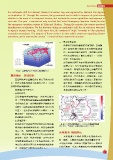

                                                               三、東北部地震帶:
                                                                    此帶係受沖繩海槽擴張作用影響,自蘭陽

                                                                    溪上游附近經宜蘭向東北延伸到琉球群
                                                                    島,屬淺層震源活動地帶,並伴隨有地熱
                                                                    與火山活動現象(龜山島附近)。(資料
                                                                    參考:中央氣象局)
                                                                    而宜蘭與花蓮正位處於東部與東北部此地

                                                                    震帶之中,每年有感地震發生次數超過
                                                                    300餘次,而地震後所引發之海嘯更不可
                  ◆ ◆圖 1◆◆臺灣地震帶◆( 中央氣象局地震測報中心 )
                                                                    忽視,猶記當年日本311大海嘯正是地震
            震害頻仍   海嘯伺起                                             後所引發,其災情慘重。有鑑於此,在此

                 臺灣因地理位置剛好處在環太平洋火山帶                                 次國家防災日以宜蘭、花蓮為主要防災演
            中,菲律賓海板塊和歐亞板塊的交界上,因此                                    練之對象,並檢驗各單位的災害搶救統合
            造成臺灣的地震頻繁。                                              作業與緊急應變能力,並貫徹災害防救法
                 臺灣地震帶主要有3:                                         及加強防災教育宣導工作。
            一、西部地震帶:

                 泛指整個臺灣西部地區,大致與島軸平
                 行。主要係因為板塊碰撞前緣的斷層作用
                 引發地震活動,由於斷層構造多侷限在地

                 殼部分,因此震源深度相對較淺(約10 餘
                 公里)。但由於西部地區人口稠密、工商
                 建設發達,因此每每有大地震發生時都會
                 造成較嚴重的災情。

            二、東部地震帶:
                 此地震帶之地震係直接肇因於菲律賓海板                              ◆ ◆圖 2◆18 種海溝型海嘯源 (T1-T18) 及 4 種斷層型海嘯源
                                                               (T19-T22) 之空間分布、名稱與地點 ( 吳祚任,2011)
                 塊與歐亞板塊碰撞所造成,地震活動頻率
                 最高。此一地震帶南端幾與菲律賓地震帶
                                                               兵棋推演  模擬評估
                 相接,並沿臺灣本島平行方向向北延伸
                                                                    兵棋推演是軍隊作戰前評估戰術的可行
                 經臺東、成功、花蓮到宜蘭,而與環太平
                                                               性、勝敗、人員及裝備損害程度的重要手段,
                 洋地震帶延伸至西太平洋海底者相連。本
                                                               可以使用地圖、沙盤或計算機等進行。將此用
                 地震帶南端與花蓮以北區域因板塊隱沒作
                                                               在防災演習,可說是將演習提升到實際的模擬
                 用,震源深度可達到300公里左右。
                                                                                                               7 7 7
   2   3   4   5   6   7   8   9   10   11   12